Theories about coral atoll formation is inconclusive. However the most prominent and perhaps most accepted one is given by the Sir Charles Darwin in 1842. According to him the base of the islands below the reef is a volcanic formation over which corals settled and built fringing reefs, which transformed to barrier reefs and finally to atolls due to geological submergence of volcanic base.

According to legends, small settlements started in the islands of Amini, Kavaratti Andrott and Kalpeni first and later people from these islands moved to other islands of Agatti, Kiltan, Chetlat and Kadmat.
The advent of Islam dates back to the 7th century. St. Ubaidulla of Mecca dreamt that prophet Mohammed wanted him to go to Jeddah, take a ship from there and go to distant places. While he was sailing near these small islands, a storm wrecked his ship. Floating on a plank he was swept ashore on the island of Amini. Ubaidulla started propagating Islam in the islands.
Still 93% of the inhabitants of Lakshadweep are Muslims.

People are mostly engaged in fishing and coconut cultivation. The islands are virtually crime-free
FORMATION AND GROWTH OF ISLANDS
The islands on these atolls are invariably situated on the eastern reef margin except Bangaram and Cheriyakara which lie in the centre of the lagoon. On Bitra, the island is on the northern edge of the lagoon. The atolls Show various stages of development of the islands, the reefs at Cheriya panniyam, Perumalpar and Suheli represent, the earliest stage while Kalpeni, Kavaratti, Agatti and Kadmat are in intermediate stage and Chetlat and Kiltan are in an advanced or mature stage of development. The development and growth of the islands on eastern reef margin has been controlled by a number of factors. The cyclones from the east have piled up coral debris on the eastern reef while the very high waves generated annually during the southwest monsoon have pounded the reef and broken this into coarse and subsequently to fine sediments which was then transported and deposited on the eastern side behind the coral boulders and pebbles on the eastern reef. A gradual accretion of sediments by this process has led to the growth of the islands. Even the atolls where the islands are not yet fully developed (Suheli, Valiyapanniyam and Bitra) sandy cays occur on the eastern reef margin. In some of the lagoons like Kiltan and Chetlat the islands are growing at a very fast rate and during the next decade the lagoon itself may be filled up with sediments. In such atolls where openings occur in the reef or where the lagoon is too wide for the sand to be transported across its entire width. sand banks usually develop and enlarge towards the centre of the lagoon leading to the formation of the island in the centre such as in Bangaram and Suheli etc.
The islands do not have any rivers or creeks but some brackish water ponds occur at Bangaram and Minicoy. At Bangaram the pond has been formed during the process of growth of the Islands where the outlet of the bay has been blocked by sand. At Minicoy, a similar pond was being formed at the southern edge but a bund has been constructed and this has created an artificial brackish water pond.
Storms and Cyclones
Surrounded by the vast ocean, the islands are open to storms and cyclones. One of the earliest natural calamities recorded was the great storm that struck the islands in April, 1847. It commenced in Kalpeni about 8 p.m. on 15th April, passed on to Androt and finally reached Kiltan after devastating these two islands. All the houses in Kalpeni were damaged and many were entirely washed away. The population of that island prior to the hurricane was reckoned at 1642. Of these, 246 were drowned or washed away by the storm. One hundred and twelve perished in the ensuing five months from famine or from the diseases engendered by unwholesome and insufficient food, 376 escaped to the coast, leaving in the island 908, of whom nearly four-fifths were women and children. The plantations in the island were completely destroyed. Out of upwards of 1,05,000 full grown coconut trees, the number before the storm, only 768 survived. In Androth, the population before the storm was 2576. Many people perished in the storm and large numbers of the survivors migrated to other islands. Those left in the island numbered only 900. The coconut trees were almost completely destroyed .
In 1891, a violent storm burst upon Kavaratti island causing considerable damage to coconut trees. Large remissions of rent upon the cowle lands were necessitated during the next few years. The storm did a great deal of damage in Agatti and its attached islets and the Amindivi group of islands. But the damage done by the storm was not so great in these islands as in Kavaratti. 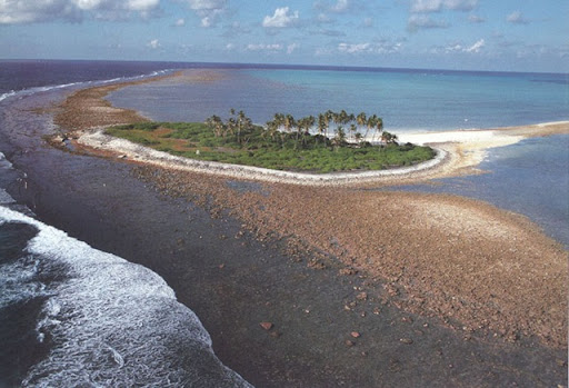
Kalpeni island was hit by a severe cyclone on Ist December, 1922. The waves washed completely over the narrow northern end and the sea poured across the island into the lagoon. The people in the northern part of the island had to flee for safety and all rushed to the mosque to pray. Fortunately the storm subsided without doing any serious damage beyond blowing down a few trees. The cyclone was scarcely felt in any other island except Suheli and to a slight extent Androth.
Another major storm which hit the islands occurred in 1941. Kavaratti was the island most affected by this storm. In 1963, a cyclone of mild intensity struck Androth island and 540 coconut trees were uprooted. The major calamity in recent times was the storm that hit the territory in December, 1965 causing considerable damage in Androth and Kalpeni islands. About 11,500 coconut trees were uprooted in Androth and about 9,500 trees in Kalpeni. Though the storm was felt in Kavaratti, Agatti and Kiltan, it was not so vehement in these islands. Government sanctioned a grant of about Rs. 14,000 in kind towards relief to the victims, in addition to a loan of nearly Rs. 31/2 lakhs.
|
The Islands of Lakshadweep
Lakshadweep islands are the only coral islands of India. They are a vastly scattered group of the coral islands that are 36 in total. Lakshadweep is an exciting tourist destination and the most new attraction of India. Kadmat, Agatti, Kavaratti, Bangaram, Kalpeni, and Minicoy are the famous tourist islands. Read more…
Water Sports at Lakshadweep
The beautiful scenery of Lakshadweep that includes grand lagoons, silver seashores, incessant miles of sun soaked sand and lush green swaying palms with amazing aquatic flora and fauna make the experience of water sports the best experience. Water sports facilities like sailing, kayaking, paddleboats, glass bottom boats, inflatable motorboats, and water skiing are available in the islands of Kavaratti, Kadamat, Kalpeni and Minicoy. Read more…
Best Time To Visit Lakshadweep
India is proud to offer Lakshadweep to international tourists. Although, the Lakshadweep Islands are open all through the year, but there are some of them that have a certain time of visit. Read more…
Some Important Instructions For The Tourists
The Do's
Enjoy your tour to Lakshadweep with a lot of things to do. Take a sight seeing tour or experience the thrill of water sports like, Yachting, Pedal boating, Scuba diving, Canoeing, Kayaking, Snorkeling, Sunbathing and Swimming. Visit the local attractions, such as the Marine museum, Light House, Sports Clubs and a few coral industries.
The Don'ts
Litter the land or water of Lakshadweep
Taking away any coral. It is a punishable crime.
Consumption of alcoholic beverages. It is totally prohibited and is a punishable crime on all islands except Bangaram.
Swim or sunbathe nude is punishable offence
To pluck tender coconuts yourself.
To put your body part out of the boat
Go out of the island lagoon without permission
To not to have permit while visiting Lakshadweep
Lakshadweep, located near Kerala, is an archipelago of 36 coral islands. It consists of 12 atolls, 3 reefs and 5 submerged banks. It lies on the Arabian Sea in the hub of the Arabian-African-Asian trade routes. It is a sort of navigator's compass to see. The name 'Lakshadweep' holds a meaningful significance. The word 'Laksha' means 1,00,000 in Sanskrit and Malayalam (regional language of Kerala). In fact this word is symbolic. The islands of Lakshadweep do not count up to one lakh as such. It has a symbolic meaning. 'Dweep' is the Hindi word for islands. Hence, Lakshadweep can mean "Lakhs of Islands".
The Lakshadweep Island are simply beautiful, untouched and unspoilt. By now the tourists all over the world know quite little about them. This serene and peaceful environ of Lakshadweep makes it really special. Whether you take a holiday package to Lakshadweep or Adventure tour to Lakshadweep, you are going to enjoy it all and all.
As your flight from the mainland of India reaches to the Lakshadweep archipelago, you get the most picturesque scene of your life ever. Just fly over limitless sea and sandy landscape to see the beauty unfolding before you. Everything that you expect out of a tropical paradise-vast beaches, silver sand, palm stretches, peace and sunshine-it has it all. Above all the attractions of Lakshadweep on land lies the blue sky. Under the sea are the rich coral lagoons.
History of Lakshadweep
There are many different theories about how the Lakshadweep Islands were formed. The most prominent and accepted one among them is given by the famous English evolutionist, Sir Charles Darwin in 1842. He was of the opinion that below the reefs in the base of these islands is a volcanic formation. Over this formation the corals get settled and get formed in the shape of fringing reefs. Further they get turned into barrier reefs and afterwards atolls because of geological submersion of the volcanic base.
Islam made inroads into local Lakshadweep culture sometime in the 7th century. St. Ubaidulla of Mecca, after he dreamt that prophet Mohammed wants him to visit Jeddah, took a ship and traveled to distant places. On his journey, he sailed near the small islands of Lakshadweep and his ship was wrecked by a storm. He saved his life by floating on a plank. He spend his night ashore the Amini Island. Afterwards, he stayed here and began to propagate Islam in these islands.
According to legends, people in small settlements began to line in the islands of Kavaratti, Amini, Andrott and Kalpeni. Later they moved on to the other islands of Agatti, Chetlat, Kiltan and Kadmat.
Travel tour to Lakshadweep
With Taj Mahal Tourism, you can enjoy many interesting tours to Lakshadweep. The main attraction here is water adventure sports. The great cover of coral reefs offers vast areas of crystal clear waters that are perfect for wind surfing as well as snorkeling. Only five islands of Lakshadweep are open for tourists. They offer plenty of comfortable accommodation options in the beach cottages.
The islands are fringed by snow-white coral sands and appear like emeralds in the incessant blue sea. The diverging hues of translucent turquoise blue water surround them. The Coral atolls provide the visitors unmatched marine environment with numerous colors. This results in composite interaction of inanimate and animate things. They are the only coral islands of India that are made due to slow acculturation of calcium by corals from water and turning it in reefs.
How to reach Lakshadweep
Lakshadweep islands are 400 kms far in the west coast of Kerala. From India, you can either board regular flights or ships that run between Agatti Island and Cochin in Kerala. You can find many flights catering to Lakshadweep. Indian Airlines operates its daily flight to Agatti except Sundays. Also, the ships are also easily available that sail to the main islands of Lakshadweep in a series.